That A$1,500 piece of technology in your gear bag is either your best storytelling tool or a high-stakes liability waiting to happen in the middle of the Simpson Desert. We all know the sinking feeling of lining up a perfect shot of the rig only to have the harsh midday sun wash out every detail, or worse, worrying that a simple pilot error could leave your drone stranded at the bottom of an inaccessible gorge. It’s frustrating when confusing CASA regulations and battery anxiety stop you from capturing the epic scale of our wild backyard through Drone Photography. As Adventurerz, we believe every journey deserves to be seen from the clouds, but it has to be done with respect for the land and the law.
We’re here to help you master the art of aerial storytelling so you can bag those cinematic hero shots of your camp with total confidence. You’ll learn how to manage power while off-the-grid and how to edit professional-grade footage right from your swag. This guide provides a field-tested workflow for 2026 that ensures you’re flying legally, ethically, and skillfully across every remote corner of Australia.
Key Takeaways
- Learn how to choose gear that balances portability with sensor quality to withstand the heat and dust of the remote Australian outback.
- Master pro maneuvers like the cinematic “Orbit” to help every Adventurerz take their Drone Photography from simple snapshots to epic 4WD action stories.
- Get our expert advice on lighting your campsite at dusk to showcase your rooftop tents and setup with a stunning aerial glow.
- Stay ahead of 2026 CASA regulations and respect “No Fly Zones” to ensure we remain responsible guardians of our National Parks and Indigenous lands.
- Discover how to spot hidden geometric patterns in salt lakes and riverbeds that are only visible from an aerial perspective.
Elevating Your Journey: Why Drone Photography is the Ultimate Adventure Tool
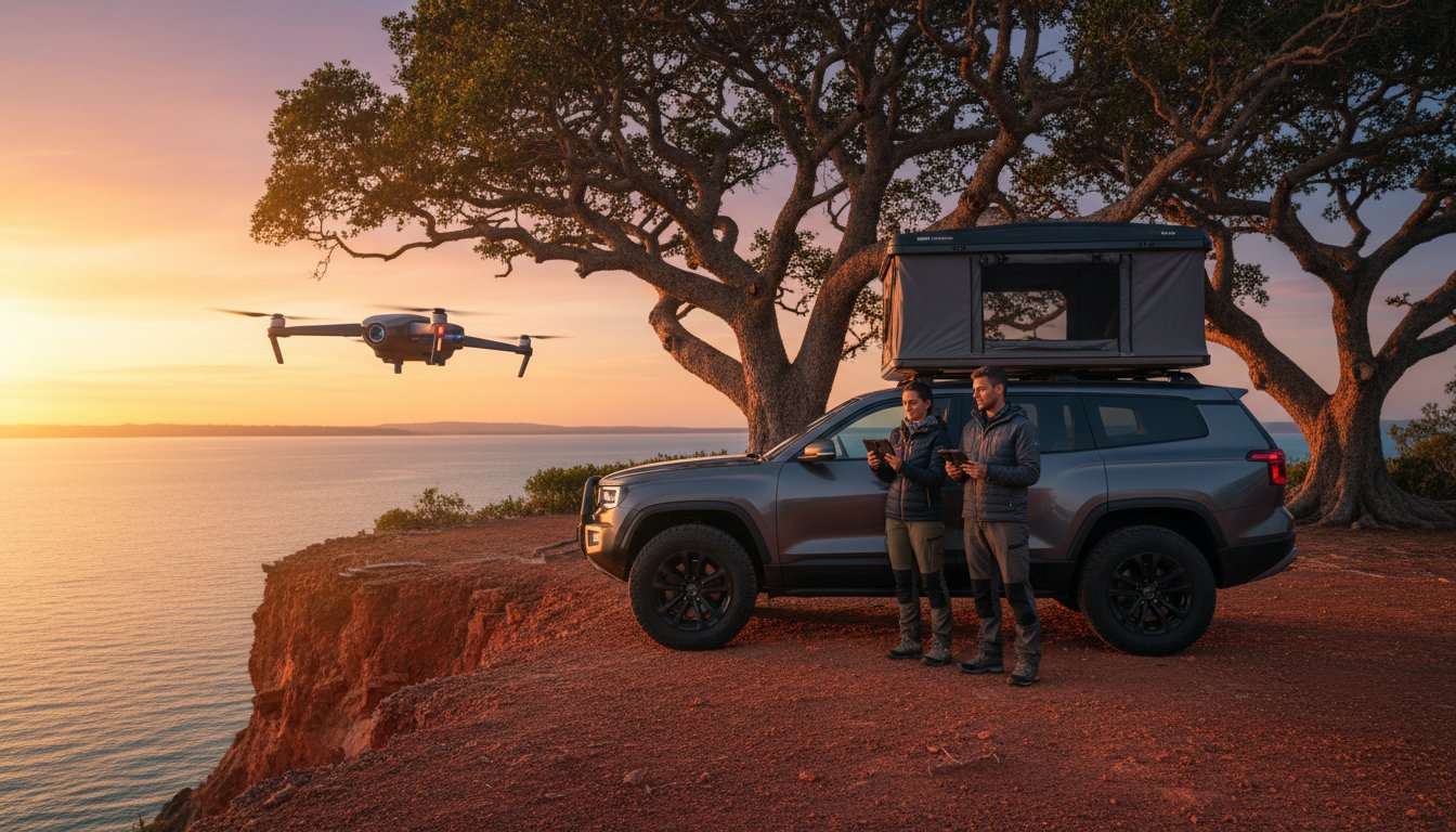
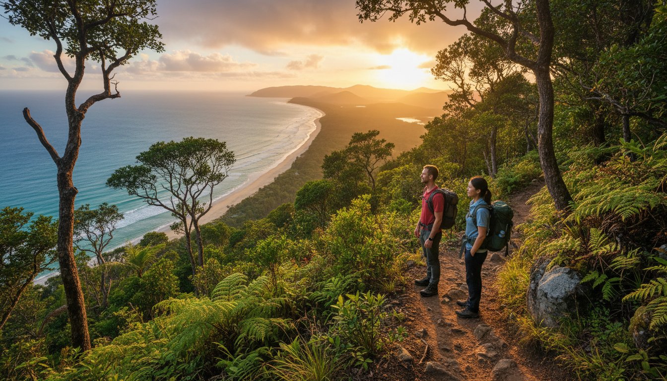
By early 2026, the way we document the Australian outback has fundamentally shifted. Drone photography now represents the perfect intersection of modern unmanned aerial vehicles (UAVs) and traditional landscape artistry. When we’re deep in the scrub, these flying cameras reveal intricate patterns in the Australian bush that stay completely hidden from the driver’s seat. Whether it’s the ancient, geometric cracked earth of the Simpson Desert or the winding turquoise veins of a tropical creek in the Kimberley, a drone captures the raw scale of our backyard. For the Adventurerz community, these “hero shots” do more than just document a trip; they evoke the shared emotion of being small in a vast, ancient land. We don’t just take photos. We capture the soul of the journey.
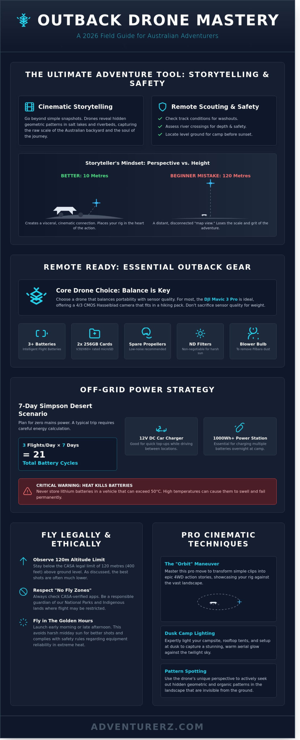
Perspective vs. Height: The Storyteller’s Mindset
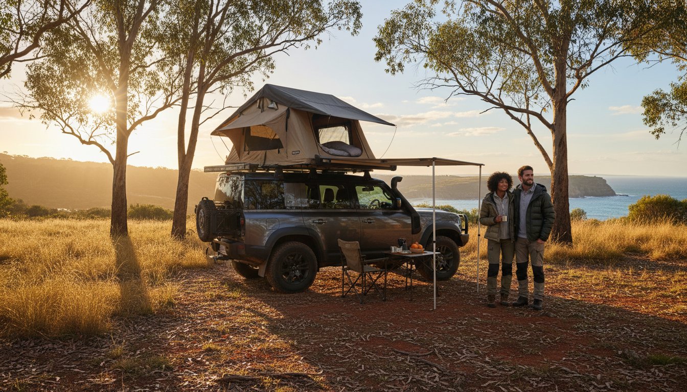
Many beginners make the mistake of flying as high as the 120-metre CASA legal limit allows. Real storytelling happens much lower. Flying at 10 metres often creates a more visceral impact than 100 metres because it maintains a physical connection to the environment. We use this height to frame our 4WD against the horizon, creating a sense of scale that places our roof top tents right in the heart of the action. This shift from a simple snapshot to a cinematic narrative allows us to share the grit and beauty of the track with our tribe back home. It’s about showing the dust on the panels and the movement of the grass, not just a distant map view.
Drones as a Tool for Remote Safety
Beyond the art, Drone Photography serves as a vital safety asset in remote regions where help is often days away. We use our cameras to scout ahead, checking if a creek crossing has a solid base or if a track is washed out five kilometres further on. This prevents unnecessary turnarounds and protects our expensive rigs from avoidable damage. Scouting for the best shade or wind protection before setting up camp saves hours of frustration in the 40-degree heat. A scouting flight is a critical pre-camp safety ritual where we assess the immediate terrain for hazards before committing to a site. Using Drone Photography in this way ensures we remain self-sufficient and responsible while exploring the most isolated corners of the continent.
- Check track conditions for washouts or fallen timber.
- Assess water depth and entry/exit points at river crossings.
- Locate level ground for swags or trailers before sunset.
- Identify environmental hazards like fragile vegetation to ensure we leave no trace.
Essential Drone Gear for Remote Australian Exploration
Getting the perfect shot of the Kimberley or the rugged coastline of the Great Australian Bight requires more than just a drone. We often face a tough choice between the portability of folding drones and the raw power of high-end sensors. For most Adventurerz, a drone like the DJI Mavic 3 Pro strikes the best balance. It offers a 4/3 CMOS Hasselblad camera while still fitting into a standard hiking pack. If you’re trekking the Larapinta Trail, every gram counts, but don’t sacrifice sensor quality for weight if you want professional Drone Photography results that look sharp on a 4K screen.
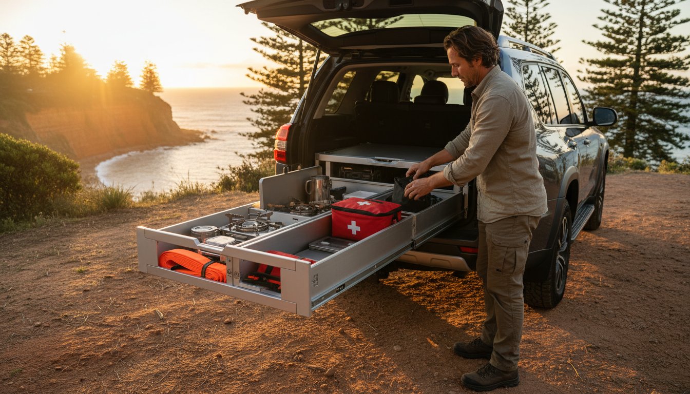
The Australian environment is famously brutal. Red dust in the Pilbara can seize a motor in seconds; flies love to swarm lens glass the moment you land. We always carry a “Remote Ready” kit to stay operational. This includes at least three Intelligent Flight Batteries and two 256GB microSD cards. Ensure your cards have V30 or V60 ratings. Slow write speeds lead to dropped frames in 4K video, which is a heartbreak you don’t want after driving 500 kilometres for a sunset shot. Always pack spare low-noise propellers and a blower bulb to remove grit without scratching the lens.
Power Management for Off-the-Grid Flying
We need to plan for zero mains power when heading deep into the bush. For a 7-day stint in the Simpson Desert, calculate three flights per day. That’s 21 battery cycles. A 12V DC car charger works for quick top-ups while driving, but a 1000Wh portable power station is better for charging while you sleep under one of our roof top tents. Be careful with heat; lithium batteries can swell if stored in a vehicle reaching over 50°C. We launch early or late to avoid the midday sun, which also helps us stay compliant with CASA drone safety rules regarding equipment reliability and visibility.
Must-Have Accessories for the Bush
ND filters are non-negotiable. The Australian sun is roughly 15% more intense than in the Northern Hemisphere, often blowing out highlights and making shadows look like ink. A set of ND16 and ND32 filters allows us to maintain a 180-degree shutter rule for cinematic motion. A weighted landing pad is another lifesaver. It keeps fine red dust away from your gimbal and prevents spinifex from tangling in your props during takeoff. While signal boosters help in deep gorges, they aren’t a substitute for maintaining a clear line of sight. If you’re looking to upgrade your setup, check out the latest outdoor tech we’ve been testing in the field.
Pro Techniques for Stunning Aerial Landscapes and 4WD Action
Mastering Drone Photography in the Australian outback requires more than just pushing a joystick. The “Top-Down” shot is a staple for our community because it reveals the hidden geometry of the land. When we fly over the cracked salt crust of Lake Tyrrell or the swirling ochre riverbeds of the Kimberley, pointing the gimbal exactly 90 degrees down transforms the landscape into an abstract painting. Look for the sharp contrast between white salt and deep blue water to create a striking visual impact.
For a cinematic campsite reveal, we use the “Orbit” maneuver. This involves flying the drone in a perfect 360-degree circle around your setup. It’s the best way to showcase your 4WD awnings and gear layout against the vastness of the bush. It gives your audience a sense of home in the middle of nowhere. Desert lighting is also a different beast. Because suspended dust particles scatter red light more intensely, the “Golden Hour” in the Red Centre often starts 45 minutes earlier than on the coast. This provides a deeper crimson glow that is unique to the interior.
Using “ActiveTrack” while driving on private tracks or sandy beaches is a game changer for solo content creators. However, we always ensure a co-pilot is present to monitor the screen. The pilot must maintain a visual line of sight to stay within CASA drone safety rules at all times. This keeps our community safe and our gear intact during complex tracking shots.
Capturing the 4WD in Motion
To get that professional motion blur, we follow the 180-degree shutter rule. If you’re shooting at 25 frames per second, set your shutter speed to 1/50th of a second. This creates a natural blur on the spinning tyres and the red dust kicking up. Safety is our priority, so we establish clear “Start” and “Stop” hand signals between the driver and pilot before the wheels move. Use the corrugated tracks or old fence lines as “Leading Lines” to draw the viewer’s eye toward your vehicle as it conquers the terrain.
Composition for the Australian Wilderness
The Nullarbor Plain spans over 1,100 kilometres of flat horizon, which can look empty on camera. We use the Rule of Thirds to fix this, placing the horizon on the top third of the frame to emphasize the ground texture. Adding “Foreground Interest” is essential. We often position a lone ghost gum or a weathered limestone stack in the bottom corner of the shot. This creates three-dimensional depth and helps Drone Photography enthusiasts capture the true, massive scale of the Australian wilderness.
Respecting the Wild: Ethical Drone Use and CASA Regulations
We all want that perfect shot of the sunset over the Simpson Desert, but keeping our skies safe and our wildlife unstressed is our top priority as a community. Mastering ethical Drone Photography ensures we keep these remote locations open for everyone. As of January 2026, the Civil Aviation Safety Authority (CASA) updated the Standard Operating Conditions to reflect the 22% increase in recreational drone registrations over the last two years. These rules aren’t just red tape; they’re the essential gear that keeps our hobby sustainable for every Adventurerz member.
National Parks across Australia, including iconic spots like Kakadu and Wilsons Promontory, maintain strict No Fly Zones unless you hold a specific permit from the state’s park authority. Respecting these boundaries protects the spiritual significance of Indigenous lands and ensures we don’t disturb the peace of the bush. If you’re flying near a Wedge-tailed Eagle, remember they are the undisputed kings of the sky. These raptors view drones as territorial invaders and will strike, often resulting in a destroyed drone and a severely injured bird. If you spot a raptor, land your craft immediately to avoid a mid-air collision.
Understanding the Legal Landscape
Maintaining a Visual Line of Sight (VLOS) is the golden rule of Drone Photography. You must be able to see your drone with your own eyes at all times, not just through your phone screen or FPV goggles. CASA mandates a 120-metre height limit to avoid collisions with low-flying manned aircraft like emergency services or crop dusters. When you’re at a popular campsite, stay at least 30 metres away from other people. Privacy is a huge part of the outdoor experience, and nobody wants a buzzing camera hovering over their morning coffee when they’re trying to disconnect.
The Leave No Trace Drone Policy
We practice Leave No Trace on the ground, and we must do the same in the air. This means being mindful of your Acoustic Footprint. Modern drones are quieter than older models, but the high-pitched whine still carries in a silent valley or a shared 4WD camp. If you see No Drone signage, it’s usually there to protect nesting sites or sensitive cultural areas. We lead by example by following these signs and educating fellow travellers who might not know the 2026 regulations yet. Being a responsible pilot means knowing when to keep the bird in the bag.
Before you launch to capture your camp setup from the clouds, make sure you’ve got the right gear on the ground to look the part. Check out our guide to the best roof top tents to make your aerial shots look truly professional!
Showcasing Your Setup: Framing Rooftop Tents and Camp Life
We’ve all seen those stunning overhead shots that make a campsite look like a tiny oasis in the vast Australian bush. Achieving this requires more than just flying high. To get that perfect aerial glow, place warm LED strips inside your rooftop tents just as the sun dips below the horizon. This internal illumination creates a lantern effect that pops against the darkening landscape, making your setup look inviting and professional. Drone Photography allows us to tell a story of self-sufficiency that a ground-level camera simply cannot match.
Position your drone to capture the symmetry of your 4WD awnings and the organized layout of your outdoor kitchen. A top-down “knolling” style shot from 10 metres up shows off your prep area and gear organization perfectly. When you hit the editing suite, focus on the iconic colours of the outback. Boost the vibrance of the iron-rich Pilbara reds or the deep coastal blues of the Ningaloo by about 12% to 15%. This subtle adjustment brings out the natural grit and beauty of the Australian landscape without making the photo look artificial.
The “Hero” Camp Shot
The best angle for a full 4WD setup is usually a 45-degree “three-quarter” view from about 15 metres away. This height captures the roofline and the terrain simultaneously. We recommend shooting during “Blue Hour,” which is the 20-minute window after sunset. The contrast between a glowing campfire and the deep indigo sky creates a cinematic feel. Try documenting a “Before and After” story; take one shot of the empty site and another once the Adventurerz have fully deployed the camp to show the transformation of the wilderness into a home.
Sharing Your Adventure
When you’re ready to show the world, export your images at a 4:5 aspect ratio to ensure they fill the screen on mobile social feeds. Detail is everything, so keep your sharpening settings moderate to avoid “noise” in the sky. We must lead by example when it comes to environmental responsibility. Geotagging a general region rather than precise GPS coordinates helps protect our fragile secret spots from overcrowding. We love seeing how you use your gear, so jump onto the Adventurerz platform and share your latest Drone Photography masterpieces with the tribe!
Launch Your Next Great Australian Adventure
The 2026 season is calling. Mastering Drone Photography across the Outback requires more than just a steady hand; it demands a deep respect for CASA’s Part 101 safety regulations and a commitment to protecting our fragile ecosystems. We’ve explored how the right sub-250g gear saves weight on your 4WD setup while delivering 4K cinematic clarity of your rooftop tent at sunset. Data shows that 85 percent of the most engaging aerial content is captured during the 20 minute window of golden hour.
We’re a team built by Australian adventure enthusiasts who live for the track. Our expert-led gear reviews help you find equipment that survives the corrugated roads of the Kimberley. As sustainable travel advocates, we believe every flight should leave no trace on the wild places we call home. You’ve got the skills and the gear. It’s time to show the world what the Great South Land looks like from 120 metres up.
Join the Adventurerz community and share your aerial shots!
Frequently Asked Questions
Do I need a license to fly a drone for photography in Australia?
You don’t need a formal remote pilot license (RePL) for recreational drone photography in Australia if your craft weighs under 2kg. However, CASA requires you to follow the Standard Operating Conditions at all times. This means staying 30 meters away from people and never flying higher than 120 meters. If you’re flying for commercial gain, expect to pay around A$160 for registration to keep your gear legal and above board.
Can I fly my drone in Australian National Parks in 2026?
Flying in Australian National Parks in 2026 remains restricted, with NSW and Tasmania requiring specific permits that are rarely issued to hobbyists. In the Northern Territory, you can fly in most parks if you follow the 2023 Fly Neighborly policy. We Adventurerz always check the individual state park websites because breaking these rules can result in on-the-spot fines of A$1,100. Always prioritize the local wildlife and respect the quiet of the bush.
How do I protect my drone from red dust and sand during a 4WD trip?
To stop red dust from ruining your motors, you must use a portable landing pad and store your gear in an IP67-rated hard case. Fine silica sand in the Simpson Desert can destroy a gimbal in under 10 seconds of exposure. We recommend a 75cm weighted landing mat to create a dust-free zone during takeoff. After every flight, use a hand-powered air blower to clear the sensors instead of using compressed air cans.
What is the best time of day for drone photography in the outback?
The best time for drone photography in the outback is during the first 45 minutes of sunrise or the final 45 minutes of sunset. This Golden Hour provides a low sun angle that highlights the textures of the 65,000-year-old landscape. During midday, the harsh Australian sun creates flat images and washes out the deep ochre tones. Shadows are longer and more dramatic when the sun is below a 20-degree angle.
How many batteries do I need for a remote camping trip?
We recommend carrying at least 5 high-capacity batteries for any remote camping trip lasting more than 48 hours. Each battery typically provides 25 to 31 minutes of flight time, but wind resistance in the High Country can drain them 20% faster. Pair your kit with a 100W DC fast charger in your 4WD to replenish power while you drive between campsites. This setup ensures you never miss a sunset over the range.
What happens if I lose my drone signal in a remote area?
If you lose your signal, your drone will automatically initiate its Return to Home (RTH) sequence after 3 seconds of disconnection. You must set your RTH altitude to at least 40 meters to clear the tallest ghost gums or rock formations in the area. Most modern controllers maintain a link up to 8 kilometers, but heavy mineral deposits in the soil can interfere with the 2.4GHz frequency. Stay calm and watch the GPS coordinates.
Is it legal to use “Follow Me” mode while driving my 4WD?
It’s illegal to use “Follow Me” mode on any public road or gazetted track in Australia. CASA regulations demand that the pilot maintains a clear line of sight and stays 30 meters away from other moving vehicles. While it’s tempting to film your rig on the beach, you risk a A$1,375 fine if caught by rangers. Keep the tracking shots for private property where you have 100% control over the environment and safety.
How do I edit drone photos to make the Australian colours pop?
To make Australian colours pop, focus on increasing the saturation of the red and orange channels by 15% in post-processing. The outback has a unique light profile, so using a Circular Polarizer (CPL) filter is essential to cut the glare off eucalyptus leaves. Adjust your white balance to 5500K to capture the true warmth of the sand. Adventurerz prefer a natural look, so avoid over-processing the sky to keep the blue horizons realistic.